This package offers an R implementation of Universal Soil Loss Equation (USLE). You can find here a collection of functions to estimate main factors: R-factor, K-factor, LS-factor and C-factor. The package usesterra and Rsagacmd in the background. SAGA GIS need to be installed on your machine as well.
Disclaimer! This package is under development right now. It was tested on Windows 10 only. However, its operability fully depends on
terraandRsagacmdpackages. Therefore it is expected thatrusleRshould work on Linux-based machines as well.
Installation
You can install the development version of rusleR from GitHub with:
# install.packages("devtools")
devtools::install_github("atsyplenkov/rusleR")
Example
LS-factor
This is a basic example which shows you how to calculate LS_alpine (Schmidt et al., 2019):
library(Rsagacmd)
library(terra)

# initiate a saga object
saga <- saga_gis(raster_backend = "terra")

# load DEM
f <- system.file("extdata/dem.tif", package="rusleR")
DEM <- rast(f)

# calculate LS-alpine
ls <- ls_alpine(dem = DEM)
As a result of ls_alpine() you receive a SpatRaster object:
ls
#> class       : SpatRaster
#> dimensions  : 78, 54, 1  (nrow, ncol, nlyr)
#> resolution  : 27.30756, 27.30756  (x, y)
#> extent      : 337615.4, 339090, 4814626, 4816756  (xmin, xmax, ymin, ymax)
#> coord. ref. : WGS 84 / UTM zone 38N (EPSG:32638)
#> source      : memory
#> name        : LSalpine
#> min value   :        0
#> max value   : 114.6034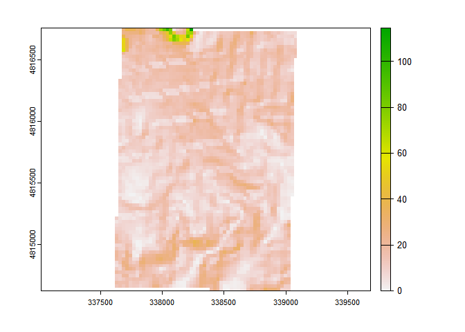
R-factor
With the help of get_glored() function you can quickly download and crop to AOI a Global Rainfall Erosivity Database map (GLORED). It was created by Panagos et al. (2017) based on in-situ measurements from 3,625 stations. This GLORED was used to develop a global erosivity map at 30 arc-seconds(~1 km) based on a Gaussian Process Regression(GPR).
library(terra)

f <- system.file("extdata/extent.shp", package="rusleR")
v <- vect(f)

r_factor <- get_glored(v)
As a result of get_glored() you receive a SpatRaster object:
r_factor
#> class       : SpatRaster
#> dimensions  : 2, 2, 1  (nrow, ncol, nlyr)
#> resolution  : 809.8197, 809.8197  (x, y)
#> extent      : 337544.9, 339164.5, 4814761, 4816381  (xmin, xmax, ymin, ymax)
#> coord. ref. : +proj=utm +zone=38 +datum=WGS84 +units=m +no_defs
#> source      : memory
#> name        :      out
#> min value   : 682.1308
#> max value   : 820.8951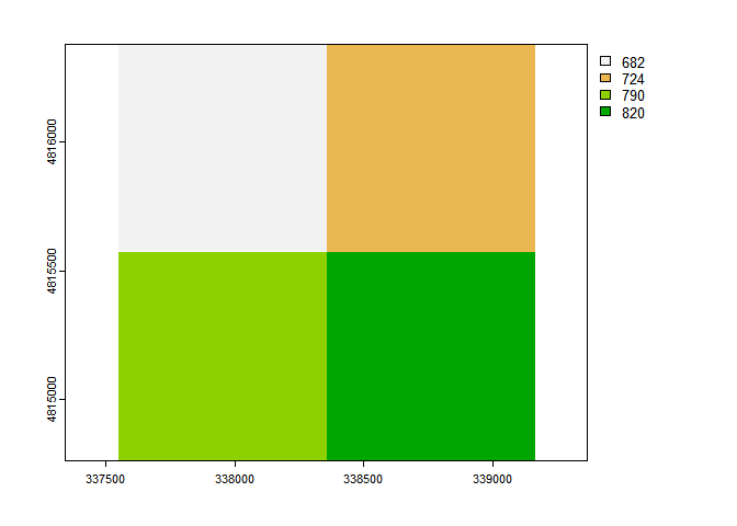
Citation
While rusleR does not redistribute the data or provide it in any way, we encourage users to cite original papers when using this package. E.g. to cite Panagos et al. (2017) when using GLORED, Hengl et al. (2017) when using SoilGrids and Schmidt et al. (2019) when using LSalpine:
Panagos, Panos, Pasquale Borrelli, Katrin Meusburger, Bofu Yu, Andreas Klik, Kyoung Jae Lim, Jae E. Yang, et al. “Global Rainfall Erosivity Assessment Based on High-Temporal Resolution Rainfall Records.” Scientific Reports 7, no. 1 (June 23, 2017): 4175. https://doi.org/10.1038/s41598-017-04282-8.
Hengl, Tomislav, Jorge Mendes de Jesus, Gerard B. M. Heuvelink, Maria Ruiperez Gonzalez, Milan Kilibarda, Aleksandar Blagotić, Wei Shangguan, et al. “SoilGrids250m: Global Gridded Soil Information Based on Machine Learning.” PLOS ONE 12, no. 2 (February 16, 2017): e0169748. https://doi.org/10.1371/journal.pone.0169748.
Schmidt, Simon, Simon Tresch, and Katrin Meusburger. “Modification of the RUSLE Slope Length and Steepness Factor (LS-Factor) Based on Rainfall Experiments at Steep Alpine Grasslands.” MethodsX 6 (2019): 219–29. https://doi.org/10.1016/j.mex.2019.01.004.
To-do list
- K-factor functions
-
tidy-loader disclaimer (see
tidyterrapackage) - New radar-based R factor (https://esdac.jrc.ec.europa.eu/themes/satellite-based-global-r-factor)
- SDR estimation (see Batista et al., 2021)
- Connectivity index (see Borselli et al., 2008)
- IC by Cavalli et al., 2013
- SDR by Vigiak et al., 2012
- C-factor????
- Should I use WhiteboxGeo tools in a backend instead of SAGA??